Friday, February 28, 2025

FAMILIA ISIYO NA MALENGO INAWEZA KUKUMBWA NA NINI?


Familia isiyo na malengo inaweza kukumbwa na matatizo mbalimbali, ikiwa ni pamoja na: 

 1. Ukosefu wa Maelewano – Bila malengo ya pamoja, kila mtu anaweza kuwa na mwelekeo wake binafsi, jambo linalosababisha migogoro na kutokuelewana. 
 2. Matatizo ya Kifedha – Bila mipango ya kifedha, familia inaweza kushindwa kusimamia matumizi, kuwekeza, au kujiandaa kwa dharura, hivyo kusababisha madeni na ugumu wa maisha. 
 3. Malezi Duni ya Watoto – Watoto wanaolelewa katika familia isiyo na malengo wanaweza kukosa mwongozo mzuri wa maisha, jambo linaloweza kuathiri maendeleo yao kielimu, kitabia, na kimaadili. 
 4. Kukosa Maendeleo – Familia inaweza kusalia katika hali ya kutoridhisha kwa sababu hakuna mipango ya kujiboresha au kufanikisha mambo muhimu kama elimu, biashara, au ujenzi wa maisha bora. 
 5. Kuvunjika kwa Familia – Bila malengo ya pamoja, upendo na mshikamano wa kifamilia unaweza kudhoofika, na hatimaye kusababisha migogoro mikubwa au hata kuvunjika kwa familia. 6. Msongo wa Mawazo na Mfadhaiko – Wanakaya wanaweza kujikuta wakikabiliwa na msongo wa mawazo kwa sababu ya maisha yasiyo na mwelekeo, hali inayoweza kuathiri afya yao ya kiakili na kimwili. 
 7. Uhusiano Mbaya na Jamii – Familia isiyo na malengo inaweza kujikuta ikikosa heshima na ushawishi ndani ya jamii, kwani haiwezi kushiriki kikamilifu katika maendeleo ya kijamii au kusaidia wengine. Ni muhimu kwa familia kuweka malengo ya muda mfupi na mrefu ili kuhakikisha maendeleo, mshikamano, na maisha bora kwa wanakaya wote.
                     Msomihuru

Thursday, February 27, 2025

VULCANICITY/VOLCANISM
What is vulcanicity/volcanism?
*Is the process where by molten material (magma) are forced into the earth crust or onto the surface.
*Is the process where by molten material are both intruded into the earth crust or extruded onto the earth surface.

INTRUSIVE FEATURES (INTRUDED, ONTO)
1.BATHOLITHS
Is the large mass of magma which occur after accumutation of molten material from the base of mountain.
Published from Blogger Prime Android App

2.DYKES
Are formed when the molten material (magma) are cooling and solidifying across the bedding plane.
Published from Blogger Prime Android App
3.SILL
Are formed when the molten material are cooling and solidifying horizontal along the bedding plane.

Published from Blogger Prime Android App
4.LACCOLITHS
Is a dome shape like a mushroom which occur when the molten material are cooling and solidifying overly.
Published from Blogger Prime Android App
5.LOPOLITH
Is a shape like soucer which formed when the molten material are increased weight over the surface causing linking of the surface.
Published from Blogger Prime Android App

6.PHACOLITH
Is a lense like structure which formed when the molten material or igneous rock are cooling and solidifying to the crust of the anticline or to the bottom of syncline.
Published from Blogger Prime Android App
EXTRUSIVE FEATURES (ONTO, EXTRUDED)
1.ASH AND CINDER CONE

It formed when the molten material (Magma) are violencely eject forced out due to high pressure and mixed with ash and cinder.
Published from Blogger Prime Android App
2.LAVA CONE
It occur when the lava are liquid or viscous usually produce gentle or slopely cone for large area.
Published from Blogger Prime Android App
3.COMPOSITE CONE
Are formed alternate layer of lava and ash after eruption of great violent and forming a small conlets.
Published from Blogger Prime Android App
4.CREATER
Is the vent on the top part when lava is spread out.

5.CALDERA
Is the large creater which formed due to strong eruption found to the top part of the depression may latter filled with water from a lava.
Published from Blogger Prime Android App
6.LAVA FLOW
Formed when lava flow out quickly through fissures and spread out over the surrounding country.

Minor volcanic eruption
1.GEYSERS
Is the eruption of hot water and superheated water and spread up to height of 45 meters from the earth surface.
2.HOTSPRING
Is the eruption of hot water without any explosion.

Tuesday, February 25, 2025

MPANGO WA UFUNDISHAJI WA SOMO LA SAYANSI NA TEKNOLOJIA MADA YA USANISINURU

Mpango wa Somo: Usanisinuru

Darasa: Sita
Muda: Dakika 40
Mada: Usanisinuru
Somo: Sayansi na Techolojia

Malengo ya Somo:

  • Kuelewa dhana ya usanisinuru: Wanafunzi wataweza kufafanua usanisinuru na kueleza umuhimu wake kwa mimea na viumbehai wengine.
  • Kutambua viambato muhimu katika usanisinuru: Wanafunzi wataweza kutaja na kuelezea majukumu ya maji, dioksidi kaboni, mwanga wa jua, na klorofili katika mchakato wa usanisinuru.
  • Kufanya jaribio rahisi la kuonyesha usanisinuru: Wanafunzi watafanya jaribio la kuona jinsi mwanga unavyoathiri usanisinuru katika majani ya mimea.

Vifaa Vinavyohitajika:

  • Ubao mweusi, chaki, na dasta
  • Mchoro au kielelezo cha mchakato wa usanisinuru
  • Majani mabichi ya mmea (kama ya spinachi)
  • Maji safi
  • Glasi au vikombe vya plastiki vinavyopitisha mwanga
  • Chanzo cha mwanga (jua au taa ya umeme)
  • Karatasi na kalamu za wanafunzi

Hatua za Somo:

  1. Utangulizi (Dakika 5):

    • Maswali ya kuchochea fikra:
      • Nani anapika chakula chenu nyumbani?
      • Je, mmea hupata chakula chake wapi?
      • Mmea hutumia nini kutengeneza chakula chake?
    • Tangazo la somo: Eleza kwamba leo watajifunza jinsi mimea inavyotengeneza chakula chao kupitia mchakato uitwao usanisinuru.
  2. Maelezo ya Dhana (Dakika 10):

    • Fasili ya usanisinuru: Eleza kuwa usanisinuru ni mchakato ambao mimea hutumia mwanga wa jua, maji, na dioksidi kaboni kutengeneza chakula (glukosi) na kutoa oksijeni.
    • Viambato muhimu:
      • Maji: Hutoka kwenye udongo kupitia mizizi.
      • Dioksidi kaboni: Hutoka hewani kupitia matundu madogo kwenye majani yanayoitwa stomata.
      • Mwanga wa jua: Hutoa nishati inayohitajika kwa mchakato.
      • Klorofili: Pigmenti ya kijani kwenye majani inayonyonya mwanga wa jua.
    • Mchoro wa mchakato: Onyesha mchoro wa usanisinuru ukionyesha viambato vinavyoingia na kutoka.
  3. Shughuli ya Kivitendo (Dakika 15):

    • Jaribio la kuonyesha usanisinuru:
      • Hatua:
        1. Chukua majani mabichi na uyajaze kwenye glasi au kikombe cha plastiki kilichojaa maji.
        2. Weka glasi moja kwenye mwanga wa jua moja kwa moja na nyingine mahali penye kivuli.
        3. Waache kwa muda wa dakika 10-15.
        4. Waombe wanafunzi waangalie mabadiliko, kama vile mabadiliko ya rangi au mabadiliko mengine kwenye majani.
      • Majadiliano:
        • Waulize wanafunzi ni nini walichogundua kuhusu majani yaliyo kwenye mwanga na yale yaliyo kwenye kivuli.
        • Eleza kwamba mwanga wa jua ni muhimu kwa usanisinuru na kwamba bila mwanga, mimea haiwezi kutengeneza chakula chao.
  4. Hitimisho (Dakika 5):

    • Muhtasari: Rudia kwa ufupi mchakato wa usanisinuru na umuhimu wake.
    • Maswali ya kujitathmini:
      • Je, ni viambato gani vinavyohitajika kwa usanisinuru?
      • Kwa nini mwanga wa jua ni muhimu kwa mimea?
      • Ni nini kinachotokea ikiwa mmea haupati mwanga wa kutosha?
  5. Kazi ya Nyumbani:

    • Waombe wanafunzi wachore mchoro wa usanisinuru na waeleze kwa maneno yao wenyewe jinsi mchakato unavyofanyika.

Marejeleo:

  • Mpango wa Somo wa Darasa la 6 Sayansi Asilia na Teknolojia, WCED ePortal.
  • Mpango wa Somo kuhusu Usanisinuru, EduCere Centre.

Mpango huu wa somo unalenga kuwasaidia wanafunzi kuelewa na kuthamini mchakato wa usanisinuru na umuhimu wake katika maisha ya kila siku.

Kwa mawasiliano: Whatsapp no 0768569349

THE HISTORY OF MOUNT KILIMANJARO

Mount Kilimanjaro, the highest mountain in Africa at 5,895 meters (19,341 feet), is a volcanic mountain located in Tanzania. It consists of three volcanic cones: Kibo (the highest and dormant), Mawenzi, and Shira (both extinct).

Geological History

Kilimanjaro formed around three million years ago due to volcanic activity caused by the shifting of the East African Rift. Shira was the first to erupt and later collapsed, forming a plateau. Mawenzi and Kibo followed, with Kibo remaining dormant, potentially capable of future eruptions.

Human and Cultural History

  1. Indigenous Peoples: The Chagga people, who live near the mountain, have known of Kilimanjaro for centuries. They developed agriculture on its fertile lower slopes and had legends about the mountain’s snow and spirits.
  2. European Discovery: While local populations always knew about Kilimanjaro, it was "discovered" by Europeans in the 19th century. In 1848, the German missionary Johannes Rebmann was the first European to record seeing its snow-capped peak, which was initially dismissed as a myth.
  3. First Ascent: In 1889, Hans Meyer (a German geographer) and Ludwig Purtscheller (an Austrian mountaineer) became the first recorded people to reach the summit of Kibo, now called Uhuru Peak.
  4. Colonial and Post-Colonial Eras: Kilimanjaro was part of German East Africa before becoming British-controlled Tanganyika after World War I. When Tanganyika gained independence in 1961 and later merged with Zanzibar to form Tanzania in 1964, Kilimanjaro became a national symbol.

Modern Importance

  • Tourism and Climbing: Kilimanjaro is a popular trekking destination, attracting thousands of climbers each year. Unlike many high peaks, it requires no technical climbing skills.
  • Climate Change: Kilimanjaro’s glaciers are rapidly shrinking due to global warming. Some studies predict they may disappear within a few decades.
  • Cultural and National Significance: The mountain is a powerful symbol for Tanzania and Africa, representing endurance and freedom. The peak, "Uhuru" (Swahili for "freedom"), commemorates Tanzanian independence.


FORCES THAT AFFECT THE EARTH
MASS WASTING OR MOVEMENT
What is Mass wasting?
Refer to the movement of debris or loose material from weathering or bedrock down a slope.

FACTORS INFLUENCE MASS WASTING
1. Steepness of the slope
If the area or land is steeper the movement will be faster than the gentle slope
2. Weight of material
Light material lead to the faster movement than heavy material.
3. Amount of water in the material.
When there are alot of water movement will be slow than many water movement will be great.

TYPES OF MASS WASTING MOVEMENT
1. Soil creep
Is steady downward movement of soil on all sloping land
*Rain water lubricates soil particles and enable than to slide over each other. Is the slow movement but it can cause tree,fance and electrical polls are tilted down the hill
Published from Blogger Prime Android App

2.Mud flow
Is the movement of clay containing an excessive amount of water behave as a plastic mass moving as a thicky viscous fluid
Published from Blogger Prime Android App
3. Land slide
It take place when large quantities of loosen rock and soil sudden slide together down the steeper slope.
Published from Blogger Prime Android App
4. Rock fall
Is the falling of mass of rock from a steep cliff this is most rapid of all eg.Mwanza
Published from Blogger Prime Android App
EFFECT OF MASS WASTING MOVEMENT
1. Formation of fertility soil
2.Tourist attraction
3.Land degradation eg.soil erosion
4.Damage of property
5.Loss of life
6.Creation of rocks

Monday, February 24, 2025

WEATHERING
What is weathering?
Weathering is the physical or chemical disintegration of rock at the earth surface. Weathering can be classified into three type.

TYPES OF WEATHERING
1. Mechanical weathering
2. Chemical weathering
3. Biological weathering

1. MECHANICAL WEATHERING (PHYSICAL)
Is the physical disintegration and reduction in the size of the rock without changing their chemical composition. Example exfoliation, temperature change.

2. MECHANICAL WEATHERING
Is the decomposition or weakness of the rock through chemical process to form residual material example. Oxidation
*Oxidation is reaction of iron element with water and to form rust then reddis the disintegration of rock itself.

3. BIOLOGICAL WEATHERING
Is the disintegration or decay of rock and minerals caused by chemical or physical agent of organism.
Example: Rock disintegration by plant or root growth and acidic secretion.
  • Plant penetrate into cracks and crevices of rock and cause the rock split or break into smaller particles through chemical weathering
NB: Exfoliation is a pelling off the outer layer of the rock.It can occur both slowly or rapidly as a form of mass wasting.Large rock characterized by exfoliation is called exfoliation dome.
Published from Blogger Prime Android App
  • Erosion:is the physical removal and transportation of weathered material by water,wind,ice, gravity
  • Deposition (deposit):is the process by which weathered land eroded material are laid down or place in location that is from different from their source.
IMPORTANT OF WEATHERING
1. Source of land fertility
2. Tourist attraction
3. Creation of new features of rock

EFFECT OF WEATHERING
1. Damage of property
2. Loss of life(death)

DIFFERENTIAL WEATHERING
  • Rate are controlled by the type of weathering process and rock material
  • Harder rock typically weather slower than soft rock in the same environment
  • The differences in the rate of weathering due to rock type or other characteristic is called differential weathering
FEATURES FORMED UNDER WIND EROSION
1. YADANGS: Yardangs are fascinating geological formations sculpted by wind erosion, typically found in desert environments. 
Published from Blogger Prime Android App
Here are some key points about yardangs:

### **Formation Process**
- **Wind Erosion**: Yardangs are formed by the persistent action of wind erosion. The wind carries particles that abrade the softer rock, leaving behind the harder, more resistant material.
- **Shape**: They are characterized by their elongated shape and steep sides, often aligned parallel to the prevailing wind direction.

### **Types and Sizes**
- **Mega-Yardangs**: These can be several kilometers long and hundreds of meters high, found in arid regions with strong winds.
- **Meso-Yardangs**: Generally a few meters high and 10 to 15 meters long, commonly found in semiconsolidated playa sediments.
- **Micro-Yardangs**: Only a few centimeters high, formed in softer materials.

### **Examples**
- **Qaidam Desert, China**: Known for its extensive yardang fields.
- **Mojave Desert, USA**: Another region where yardangs are prominently found.

### **Significance**
- **Geological Indicators**: Yardangs provide valuable information about past climatic conditions and wind patterns.
- **Tourist Attractions**: Their unique shapes and formations make them popular spots for tourists and photographers.

2. ZEUGENS: Zeugens are fascinating geological formations found in desert environments, created by the combined action of wind erosion and weathering. 
Published from Blogger Prime Android App
Here are some key points about zeugens:

### **Formation Process**
- **Differential Erosion**: Zeugens form when layers of hard rock overlay softer rock. Wind erosion and weathering processes erode the softer rock more quickly, leaving behind ridges of the harder rock.
- **Ridge and Furrow Landscape**: This differential erosion creates a landscape of alternating ridges (zeugens) and furrows.

### **Characteristics**
- **Height and Length**: Zeugens can vary in height, sometimes reaching up to 30 meters, and can be several meters long.
- **Shape**: They often have a flat, table-like appearance due to the erosion of the softer rock beneath the harder cap rock.

### **Examples**
- **Sahara Desert**: Zeugens are commonly found in the Sahara Desert, where the harsh desert winds and temperature fluctuations contribute to their formation.
- **Namib Desert**: Another region where zeugens are prominently found.

### **Significance**
- **Geological Indicators**: Zeugens provide valuable information about past climatic conditions and wind patterns in desert regions.
- **Tourist Attractions**: Their unique shapes and formations make them popular spots for tourists and photographers.

3. ROCK PEDESTAL:A rock pedestal, also known as a mushroom rock, is a naturally occurring rock formation that looks like a tall, thin column with a wider top, resembling a mushroom. These formations are the result of differential weathering and erosion processes.
Published from Blogger Prime Android App

### **Formation Process**
1. **Differential Weathering**: The rock pedestal forms when the softer rock at the base erodes faster than the harder rock on top. This differential weathering occurs due to the varying resistance of rock layers to weathering agents like wind, water, and temperature changes.
2. **Erosional Forces**: Wind abrasion and water erosion play significant roles in shaping the pedestal. The wind carries particles that abrade the softer rock at the base, while water runoff can further erode the lower parts.
3. **Stability**: The harder, more resistant rock at the top protects the softer rock beneath it from weathering, creating the distinctive mushroom shape.

### **Examples**
- **The Yardangs**: Found in desert regions, these elongated rock formations are often accompanied by rock pedestals.
- **Goblin Valley State Park, Utah**: Known for its numerous mushroom rock formations, shaped by wind and water erosion.

### **Significance**
- **Geological Indicator**: Rock pedestals provide valuable information about the geological history and environmental conditions of the region where they are found.
- **Tourist Attractions**: These unique formations are often popular tourist spots, attracting visitors and photographers.

Rock pedestals showcase the power of natural erosional processes and stand as striking features in various landscapes around the world. 
ROCK AND THEIR FORMATION
What is rock?
Rock refer to the combination of different materials. Rock can be classified according to their formation (origin)

TYPES OF ROCK
1. Igneous rocks
2. Sedimentary rocks
3. Metamorphic rocks

1. IGNEOUS ROCKS
These are rocks which formed through the process of solidification and compacted of molten material called Magma either within or outside the earth crust.

*Why Igneous rocks refers to the mothers rock?
1. The other rock it's owe their origin
2. Formation of soil fertilite
3. It's not originated from another rock it made up itself

Characteristic of Igneous rocks 
1.
They do not occur in layer
2. Most of them are crystalline
3. They do not contain fossils
4. The origin of another rock

2. SEDIMENTARY ROCK
These rock are formed after accumutation of deposited material of rock and compacted together.The process of formating this rock is called sedimentation
It occur after accumutation of sediment material and compacted together and cementation.
                        The rock cycle


Characteristic of sedimentary rock
1
. They are non crystalline
2. Sometimes contain fossils 
3. Are found in layer
4. Originated from igneous rock
*Due to the mode of formation sedimentary rock are formed in three process like this below

1. Mechanically formed
Formed by accumutation of material deriven from other rock which have been cemented together eg.sandstone

2. Organically formed
Formed due to remains of plants and animals eg.chalks and coal

3. Chemically formed
Formed through chemical precipitation of solution eg.rocks, salts.

3. METAMORPHIC ROCK
These rock are formed when Igneous and Sedimentar rock are subjected to heat and pressure then rock change their appearance and chemical properties

IMPORTANT OF ROCK FOR HUMAN 
1
. Construction activities
2. Minerals activities
3. Tourism activities
4. Formation of soil fertilite 

Sunday, February 23, 2025

Preposition
Preposition is a word that shows the relationship between a noun or pronoun and other words in a sentence.It indicates location, direction, time, manner or other relationships

Preposition can be classified into four type like
Preposition of location:in, on, at, by with sentences.The picture is on the wall. ๐Ÿ–ผ️

Preposition of direction:to, from, up, down, in, out 
Sentences:I am heading to the conference. 

Preposition of time:at, on, during, before, after 
Sentences: We're meeting at 2 Pm. ๐Ÿ•ฃ

Preposition of manner:by, with, in
Sentence:she sings beautifully with the choir

Mastering preposition can help you express yourself 

Saturday, February 15, 2025

UPIMAJI WA KIELIMU NA AINA ZAKE
UPIMAJI WA KIELIMU
Dhana ya Upimaji wa kielimu
Ni mchakato unaotumika katika kupata data na mabadiliko ambayo mwezeshaji huweza kujua uwezo na ujuzi wa mwanafunzi na mabadiliko ya kitabia.

Malengo ya Upimaji wa kielimu
(a) kuangalia kiwango ambacho malengo ya mada yamefikiwa na mwanafunzi
(b)kuamsha ari ya mwanafunzi kujifunza zaidi
(c)kumpa mwezeshaji dira ya kumwongoza katika kuboresha ufundishaji
(d)kusaidia katika uwekaji wa kumbukumbu za kila mwanafunzi
(e) kupata taarifa za mabadiliko katika stadi, ujuzi na mwenendo wa mwanafunzi

Umuhimu wa Upimaji
Katika elimu Upimaji wa maendeleo ya mwanafunzi hufanywa ili kujua maendeleo ya mwanafunzi na hasa kujua ni kiasi gani mwanafunzi amepata stadi na maarifa yatakayomwezesha kuishi maisha bora na kuwa na manufaa katika jamii anamoishi.

Umuhimu wa Upimaji wa maendeleo ya mwanafunzi
1.kumwezesha mwezeshaji kutoa uamuzi wa mafundisho ya kila siku.
2.kujua iwapo mitaala na ufundishaji unastahiri unakidhi mahitaji ya mwanafunzi ili kusaidia katika
Kuwapanga wanafunzi ili waweze kufundishwa kulingana na uwezo wao
Kujua kama wanafunzi wako tayari kwa mafunzo mapya
  • Kuonyesha maendeleo ya mwanafunzi kwa ujumla
  • Kuamsha ari ya wanafunzi katika kujifunza
  • Kutambua sehemu maalumu zinazohitaji kurudiwa
  • Kugundua matatizo au ugumu wanaoupata wanafunzi katika kujifunza
  • Kugundua wanafunzi ambao wako nyuma
  • Kuonyesha ubora au ubovu wa ufundishaji
  • Kujua kiasi ambacho mwanafunzi amemudu katika kupata stadi za lazima
3.Kumsaidia kuboresha ufundishaji
4.Kuonyesha uwajibikaji wa mwalimu na mwanafunzi
5.Kusaidia uchaguzi wa mwanafunzi na utoaji wa vyeti.

AINA ZA UPIMAJI WA MAENDELEO YA MWANAFUNZI
Zipo aina nne za Upimaji wa maendeleo ya mwanafunzi.Aina hizo ni:
  • Upimaji awali
  • Upimaji endelevu
  • Upimaji wa mwisho au tamati
  • Upimaji tatuzi
UPIMAJI AWALI
Upimaji wa aina hii humsaidia mwalimu kuelewa mahali ambapo mwanafunzi anapaswa kuanzia katika kujifunza.hivyo unapaswa kuzingatia nyanja zote za kielimu kama utambuzi, mwenendo na vitendo anavyomudu mwanafunzi anapoandikishwa shule.hapa unaweza andaa maswali ya kuwauliza mfano utaweka picha na kuwatawala waeleze wanachokiona katika picha na kumtaka mmoja mmoja ajibu.
Fomu ya Upimaji awali

UPIMAJI ENDELEVU
Upimaji wa aina hii hutolewa wakati mwalimu anaendelea kufundisha.mfano mwalimu anapofundisha mada fulani basi anaweza kutoa zoezi au jaribio kila baada ya kufundisha kipengele kimoja.upimaji huu unalenga kuona kama mwanafunzi amemudu kipengele hicho kabla ya kipengele kinachofuata kufundishwa.Hivyo katika upimaji huu mwalimu anaweza kutumia zana zifuatazo:

1.Orodha hakiki ya kupima taaluma
Ni zana mojawapo ya Upimaji inayotumika kupima mabadiliko na mwelekeo wa mwanafunzi kimwelekeo,kiustadi na kiujuzi .
2.Mazoezi
Ni zana nyingine ambayo mwalimu anaweza kutumia kupima maendeleo ya mwanafunzi.mazoezi yanaweza kutolewa kama maswali na maelekezo ya utekelezaji ili kupima kiwango cha uelewa wa mwanafunzi kuhusiana na somo lililofundishwa.vilevile mazoezi yanaweza kutumika kama njia ya kukazia maarifa mapya yaliyofundishwa kwa kila mada.
3.Majaribio
Majaribio hupima kiwango cha ufahamu,uelewa na mabadiliko ya mwenendo na ujuzi/vitendo vya mwanafunzi katika mambo mbalimbali.jaribio linaweza kutolewa kabla ya kufundisha au baada ya kufundisha.Zana hii humwezesha mwanafunzi kuelewa uwezo wake na kumpa ari ya kujibidiisha zaidi katika kujifunza.

UPIMAJI TAMATI
 huu unatumika kujua kama wanafunzi amepata maarifa, stadi na mielekeo katika nyanja zote za kielimu kama ilivyoorodheshwa katika mhtasari wa somo husika.Upimaji wa aina hii hutolewa mwisho wa kipindi cha mafunzo au baada ya mwanafunzi kumaliza ngazi fulani ya elimu.Upimaji huu una lengo la kupima kiwango cha mafanikio kwa ajili ya kuendelea na mafunzo ya juu pamoja na kutunuku mwanafunzi cheti.

UPIMAJI TATUZI
Wanafunzi hutofautiana katika kujifunza.Kuna wanafunzi ambao huelewa haraka na wengine ambao ni wazito kujifunza.Tofauti hizo zinapojitokeza mwalimu ajaribu kufanya Upimaji tatuzi ili kuona mwanafunzi ana matatizo gani katika kujifunza kisha ayatatue.Endapo mwalimu ataona kuwa mwanafunzi anaendelea kuwa mzito katika somo itabidi afanye uchunguzi wa kina ili atatue tatizo Hilo.Lengo la Upimaji wa aina hii ni kutafuta kwa undani sababu zinazomfanya mwanafunzi awe mzito wa kujifunza ili ziwekewe mkakati wa kuziondoa.

NYANJA ZA UPIMAJI WA KIELIMU NA NGAZI ZAKE
Nyanja ni maeneo makuu ya ujuzi,matendo na mwelekeo ambao mwanafunzi anatarajiwa kuwa nayo baada ya mafunzo.Nyanja hizo ni utambuzi, vitendo na mwelekeo/mwenendo

NYANJA ZA UTAMBUZI (COGNITIVE)
Hapa tutajikita zaidi katika kipengele cha utambuzi.
Kipengele cha utambuzi huhusisha:
  • Maarifa
  • Ufahamu
  • Matumizi
  • Uchambuzi
  • Uundaji
  • Tathmini
1.Maarifa
Kinacholengwa katika kipengele hiki ni kujenga taswira ya dhana, tukio au tendo liote mzizi kwenye sehemu inayohifadhi mambo ndani ya ubongo wa mwanandamu. Mwanafunzi anatakiwa aweze kukumbuka kile alichofundishwa na kutaja kwa kauli au maandishi.

2.Ufahamu
Katika kipengele hiki mwanafunzi anatakiwa aweze:
Kutafsiri
Kufupisha
Kubashiri
Kuandika kwa muhtasari
Mifano ya vitenzi vya upimaji ni: fupisha, bashiri, andika muhtasari.
Mfano :- andika namba inayofuata katika mfululizo huu: 2,4,6,8……

3.Matumizi
Hapa kinachosisitizwa ni matumizi ya maarifa hali halisi. Mwenendo unaojengwa hapa ni ule uwezo wa mwanafunzi kutumia ujumbe, kanuni na fikra za maarifa ya ufahamu alionao katika mazingira halisi. Mfano wa vitenzi vya upimaji ni:- tumia, badili sentensi zifuatazo kuwa katika hali fulani, chambua nomino, kitenzi, onesha, kazia, n.k.

4.Uchambuzi
Kipengele hiki kinahusu;
  • Uchambuzi wa dhana
  • Tukio
  • Maarifa fulani
Katika uchambuzi, ufundishaji hulenga kumwezesha mwanafunzi kuchunguza na kutaja uhusiano wa mambo. Mifano ya vitenzi vya upimaji ni:- chambua, husianisha, fafanua, tofautisha, pangua, tenganisha, pambanua, n.k
Advertisement
Mfano: Chambua sentensi ifuatayo: Mtoto anasoma kitabu

5.Uundaji
Katika kipengele hiki, upimaji hulenga uwezo wa mwanafunzi katika kugundua, kuvumbua au kuunda jambo. Mfano: kuandika sentensi kwa namna ya kipekee, kugundua kanuni, kutoa jumuisho, n.k.
Mifano ya vitenzi vya upimaji ni:- Unda, unganisha, panga, weka pamoja, jumuisha, panga maneno yafuatayo ili yalete maana au sentensi kamili. Anapika kitamu mama chakula jikoni.

6.Tathmini
Kipengele hiki ni kama mwamvuli wa vipengele vingine vyote. Kinachoongezeka hapa ni vigezo vinavyowekwa katika upimaji wa uhalaliau ubatili wa jambo; mfano Uzuri wa jambo, n.k. mifano ya vitenzi vya upimaji ni:- tathmini, toa uamuzi, chagua, toa maoni yako, n.k. mfano: Ipi kati ya njia zifuatazo ni sahihi kuhifadhi mazingira? “kupanda miti au kulima kando kando ya vyanzo vya maji”
Mbinu na Zana za Tathmini
Tathmini ya elimu inaweza kutekelezwa kwa kutumia mbinu na zana tofauti kulingana na mahitaji ya wanafunzi ambayo ni:-
1.Kuchunguza kwa makini
2.Mitihani
3.Maswali ya dodoso
4.Mahojiano ya ana kwa ana, n.k.
          NB: Mitihani hutumika zaidi katika tathmini ya elimu

Friday, February 14, 2025

UTAMADUNI WA MTANZANIA
UTAMADUNI
Maana ya Utamaduni
Ni mfumo mzima wa maisha ya watu fulani,jamii au nchi,mila na desturi zao za asili,jadi au Imani.Utamaduni hutambulisha na kuwaunganisha watu wa jamii husika kwa njia ya lugha, chakula,mavazi, nyimbo, michezo, Mila na desturi.

UTAMADUNI WA MTANZANIA
Ni mfumo wa maisha ya watanzani jinsi wanavyoishi kwa kufuata mila, desturi,jadi, Imani michezo na maendeleo yao kijamii,kiuchumi na kisiasa.Tanzania inamakabila yasiyopungua 120 yote yana mila na desturi zao za namna tofauti.Aidha utamaduni wa MTANZANIA umeunganishwa na lugha moja ya kiswahili ambayo ni lugha ya Taifa na ni lugha ya mawasiliano katika nchi za Afrika ya Mashariki.

VIELELEZO VYA UTAMADUNI WA MTANZANIA
Utamaduni wa Mtanzania unajitokeza katika mambo mbalimbali kama vile lugha,mila, desturi, michezo, Sanaa na mavazi.

LUGHA:Ni chombo cha mawasiliano ambacho hutumika kama utambulisho wa jamii katika kuelimisha,kupashana habari na kubadilishana mawazi

MILA:Ni jumla ya mambo yanayofanywa na jamii husika kulingana na asili, mazingira na mienendo ya jamii hiyo.mfano wa mila ni jando na unyago

DESTURI:Ni mambo ya kawaida yanayofanywa mara kwa mara na wanajamii;Pia huweza kubadilika kulingana na mahali na wakati.mfano jamii zingine hutambuliwa kulingana na mavazi,vinywaji na vyakula

MICHEZO:Ni mambo yafanywayo kwa ajili ya kujifurahisha,kujichangamsha au kupitisha wakati.kwa Tanzania kuna aina mbili za michezo ambayo ni michezo ya jadi na michezo ya kisasa.michezo ya jadi ni kama vile kurusha mkuki,kucheza BAO,kukimbia,kubembea na kuruka Jamba.michezo ya kisasa ni kama vile mchezo wa ngumi, mchezo wa kuogelea na michezo mingine.

SANAA:Ni ufundi anaoutumia mtu ili kuwakilisha fikra au mawazo yake katika namna inayoburudisha na kufikirisha.tunaweza kuiona kazi ya sanaa kupitia fasihi,uchoraji,ususi,ushonaji,uchongaji na ufinyanzi
Sanaa hizi zimegawanyika katika makundi matatu ambayo ni

(a) Sanaa za maonyesho mara nyingi huoneshwa kwa umbo maalumu za zinaweza kuhifadhiwa kwa matumizi ya baadaye.mfano ufinyanzi.

(b)Sanaa ghibu ni zile sanaa zisizoonekana katika umbo maalumu au kushikika bali hugusa hisia mfano ushairi,uimbaji na muziki.

(c)Sanaa za vitendo huonekana katika uzuri wa umbo na hufanyika kwa vitendo mfano uigizaji,vichekesho,majigambo na nyimbo

UMUHIMU WA UTAMADUNI KWA MTANZANIA
1.Ni alama ya umoja wa kitaifa na utambulisho wa jamii.
2.Hudumisha uhusiano katika jamii kwa kutunziana heshima iliyopo
3.Husaidia jamii kuthamini rasilimali za Taifa letu
4.Hutunza maadili ya malezi ya watoto,vijana na wazee
5.Husisitiza uvaaji wa mavazi ya heshima
6.Hususitiza uwajibikaji miongoni mwa wanajamii ili kukuza uchumi
7.Huepusha kudharau tamaduni zetu na kuiga za kigeni
UMUHIMU WA MILA NA DESTURI
1.Kusisitiza kushiriki katika kufanya kazi kwa juhudi na maarifa
2.Kusaidiana na kutatua migogoro ya jamii
3.Kukemea kuiga tamaduni za kigeni zinazokwenda kinyume na tamaduni zetu
4.Kusaidia kuendeleza mila na desturi nzuri kwa Taifa
5.Kujenga ari ya kujitegemea

MAMBO YANAYOATHIRI UTAMADUNI
1.Maendeleo ya sayansi na teknolojia yanaweza kuathiri utamaduni
2.Mabadiliko ya mazingira kama vile ukame huathiri uzalishaji wa mazao hasa chakula
3.Kukua kwa lugha ya kiswahili kumechangia katika kuathiri lugha za makabila mengi
4.Mwingiliano baina ya nchi yetu na mataifa ya kigeni
5.Kushamiri kwa vipindi vingi visivyokuwa na maadili ya kitanzani katika televisheni,redio,magazeti na mitandao ya kijamii

NAMNA YA KUDUMISHA MILA NA DESTURI NZURI
1.Wazee wanapaswa kutumiwa kikamilifu kukusanya taarifa za jamii husika
2.Wazee wanapaswa kuweka mikakati ya kutangaza mila na desturi zao za zamani ili watanzani wengine wazitambue
3.Kuweka mikakati ya kuanzisha vituo vya kuhifadhi taarifa mbalimbali kuhusu mila na desturi za kila kabila

Friday, February 7, 2025

PANDE KUU ZA DUNIA
Maana ya pande kuu za Dunia
Ni alama za msingi za mwongozo zinazotumika kuonesha uelekeo wa sehemu tofauti za dunia. Uelekeo huo ni kaskazini Kusini Mashariki na Magharibi. Alama za pande kuu za Dunia mara nyingi huoneshwa kwenye ramani dira na nyenzo mbalimbali za usafiri ili kumsaidia kufahamu eneo mahususi lilipo na kuweza kulifikia. Pande kuu za Dunia zinaunda msingi wa pande nyingine zaidi za dunia.
Mchoro kuonesha pande nne kuu za Dunia 


NJIA ZA KUBAINI PANDE KUU NNE ZA DUNIA
Pande kuu za Dunia zinaweza kubainishwa kwa kutumia njia mbalimbali kama vile
(i) Kubaini pande kuu za Dunia kwa Kutumia mawio na machweo ya jua
(ii) Kubaini pande kuu za Dunia kwa Kutumia uelekeo wa kivuli
(iii) Kubaini pande kuu za Dunia kwa Kutumia uelekeo wa nyota
(iv) Kubaini pande kuu za Dunia kwa Kutumia ramani.
(v) Kubaini pande kuu za Dunia kwa Kutumia dira


(i) Kubaini pande kuu za Dunia kwa Kutumia mawio
Kuangalia jua linapochomoza wakati wa asubuhi na jioni unaweza kubaini pande kuu za Dunia. Hivyo wakati wa asubuhi ukisimama kuliangalia jua linapochomoza upande huo ni Mashariki na upande wako wa kulia huwa kusini na upande wako wa kushoto huwa kaskazini na Magharibi huwa nyuma ya mgongo wako. Vilevile ukisimama kuliangalia jua linapozama jioni upande huo ni Magharibi na upande wako wa kulia huwa kaskazini na upande wako wa kushoto huwa kusini.

(ii) Kubaini pande kuu za Dunia kwa Kutumia uelekeo wa kivuli
Uelekeo wa kivuli chako wakati wa asubuhi na jioni unaweza kubaini pande kuu za dunia.Kwa kawaida unapotembea wakati wa asubuhi upande ambao kivuli chako kilipo ndio Magharibi na unapotembea wakati wa jioni upande ambao kivuli chako kilipo ndio Mashariki.
NB: Vigumu kufanya utambuzi wa pande kuu za Dunia wakati wa mchana kwa kuangalia uelekeo wa kivuli chako.
Picha ya kubaini pande kuu za dunia kwa Kutumia uelekeo wa kivuli

(iv) Kubaini pande kuu za Dunia kwa Kutumia ramani
Ramani ni mwongozo mmojawapo unaotumika kubaini pande kuu za Dunia. Miongoni mwa vipengele muhimu vya ramani ni alama ya uelekeo wa kaskazini na hutumika kurahisisha kubaini pande kuu za Dunia yaani Kaskazini, Kusini ,Mashariki na Magharibi.
Mchoro wa ramani kuonesha uelekeo wa kaskazini 

(v) Kubaini pande kuu za Dunia kwa Kutumia dira
Dira ni kifaa kinachotumiwa kutambua uelekeo wa kaskazini.Zipo aina mbili za dira ambazo ni
(i)Dira ya kidijitalia hutumia teknolojia kuonesha uelekeo na imeunganishwa kwenye GPS saa za kisasa simu janja na vyombo vya usafiri kama magari boti na ndege
(ii)Dira ya analojia ambayo hutumia vipande vya sumaku au sindano yenye sumaku kuelekeza upande wa kaskazini.
C
Mchoro kuonesha dira ya kidijitalia 


PANDE NANE ZA DUNIA
Pande nane za Dunia hutoa mielekeo minne zaidi ya pande kuu za Dunia.Mielekeo hiyo ni Kaskazini -Mashariki, Kusini-Mashariki, Kusini -Magharibi na Kaskazini -Magharibi. Pande hizi zinatoa maelekezo ya kina au uelekeo mahususi na sahihi zaidi kuhusu mahali. Kwa kawaida hutumiwa katika nyanja mbalimbali kama vile usafiri wa anga au majini, jiografia na utabiri wa hali ya hewa
Mchoro kuonesha pande nane za Dunia 


UMUHIMU WA PANDE NANE ZA DUNIA
1.Husaidia kubaini uelekeo wa mahali katika ramani na uso wa dunia
2.Huwasaidia wahandisi na wasanifu majengo katika kufanya ubunifu wa majengo, Barabara na reli.
3.Husaidia katika kuongoza vyombo vya usafiri
4.Husaidia kuimarisha ulinzi na usalama.


Thursday, February 6, 2025

MATUMIZI YA RAMANI
Published from Blogger Prime Android App
Maana ya ramani
Ramani ni mchoro ambao huchorwa kwenye karatasi, ubao laini na mnyoofu, vipande vya nguo,ukutani na sehemu Ramani huchorwa kwa njia mbalimbali kama vile kwa mkono na kwa kutumia programu na mifumo ya kompyuta.Uchoraji wa ramani hutegemeana na matumizi.

Aina za ramani
Kuna aina mbili za ramani ambazo
1.Ramani za jumla
Hizi ni ramani zinazotoa taarifa za jumla kuhusu eneo fulani.ramani hizi hazitoi taarifa moja pekee bali hutoa taarifa mbalimbali za eneo husika mfano Barabara,mito,mipaka ya kiutawala, makazi ya watu milima na uoto.Ramani za jumla ni kama vile Ramani za topografia, Ramani za kisasa, Ramani za Barabara na reli
Ramani za topografia
Hizi ni ramani zinazowakilisha mwonekano wa maumbo mbalimbali ya asili na ya kutengenezwa na binadamu yanavyoonekana katika uso wa dunia mfano bahari,tambarare,mabonde,milima,uoto, majengo na Barabara
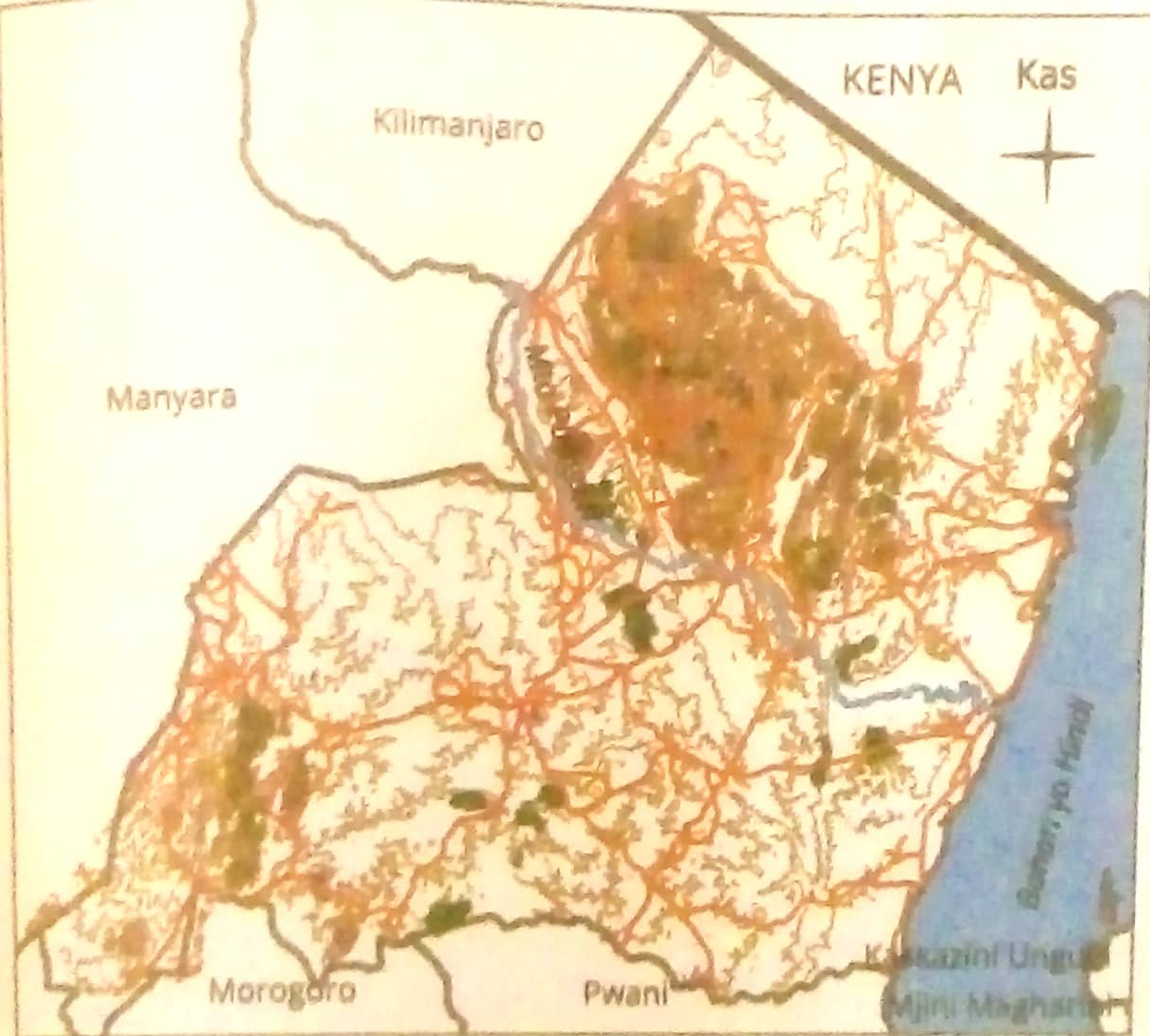
RAMANI YA TOPOGRAFIA YA MKOA WA TANGA

Published from Blogger Prime Android App

Ramani za kisasa
Hizi ni ramani zinazotoa taarifa kuhusu mipaka ya nchi,mikoa wilaya na maeneo mengine ndani ya nchi
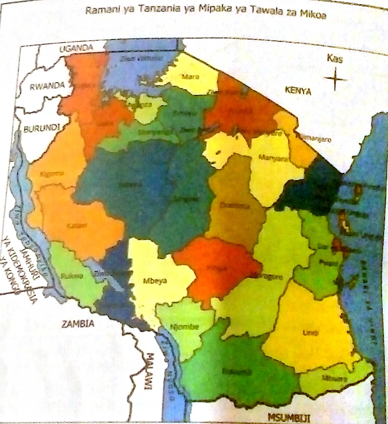
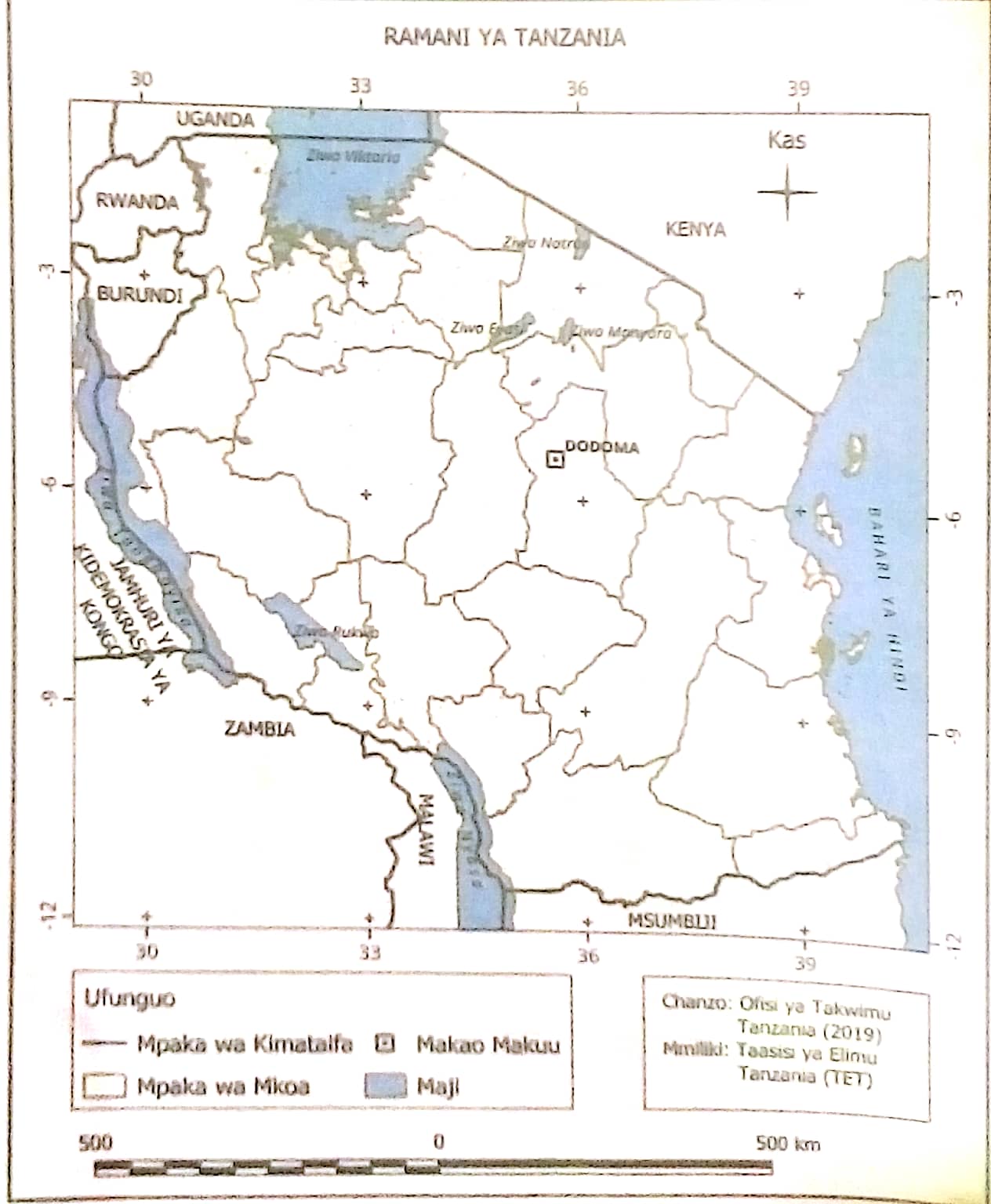
RAMANI YA TANZANIA KUONESHA MIPAKA YA TAWALA ZA MIKOA
Published from Blogger Prime Android App

Ramani za Barabara na reli
Ramani hizi zinatoa taarifa muhimu kuhusu mitandao ya Barabara na reli kama vile Barabara kuu,mitaa na alama muhimu za eneo fulani
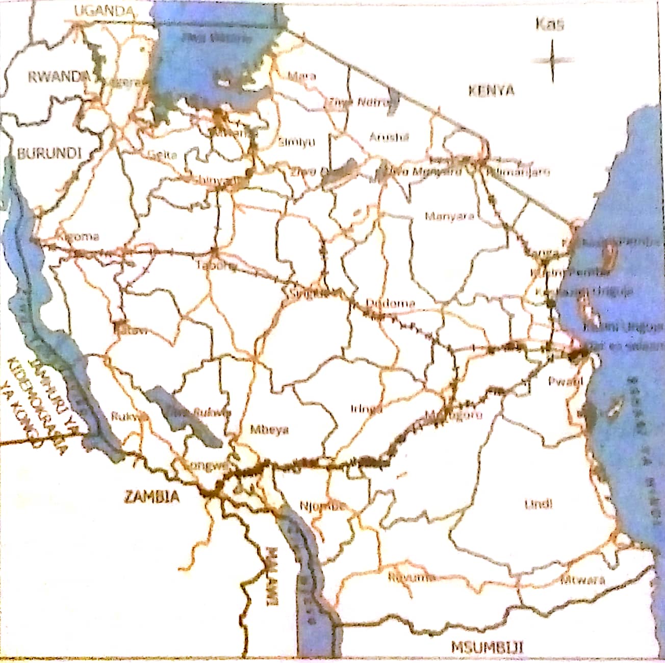
RAMANI YA MTANDAONI WA BARABARA NA RELI TANZANIA
Published from Blogger Prime Android App

2.Ramani za thematiki
Hizi ni ramani zinazowasilisha mada au taarifa moja maalumu au pekee.Ramani hizi zinaweza kuwa za kuwasilisha aina za udongo, uoto, mazao, idadi ya watu hali ya hewa na mipango miji.

VIPENGELE MUHIMU VYA RAMANI
1.FREMU:Ni mpaka au mstari wa nje unaozunguka ramani.Fremu inasaidia kuweka wazi mipaka ya ramani na kuitenganisha na taarifa nyingine kwenye ukurasa.
2.KICHWA CHA RAMANI:Husaidia kuitambulisha ramani kwa msomaji kuwa ramani inahusu nini.
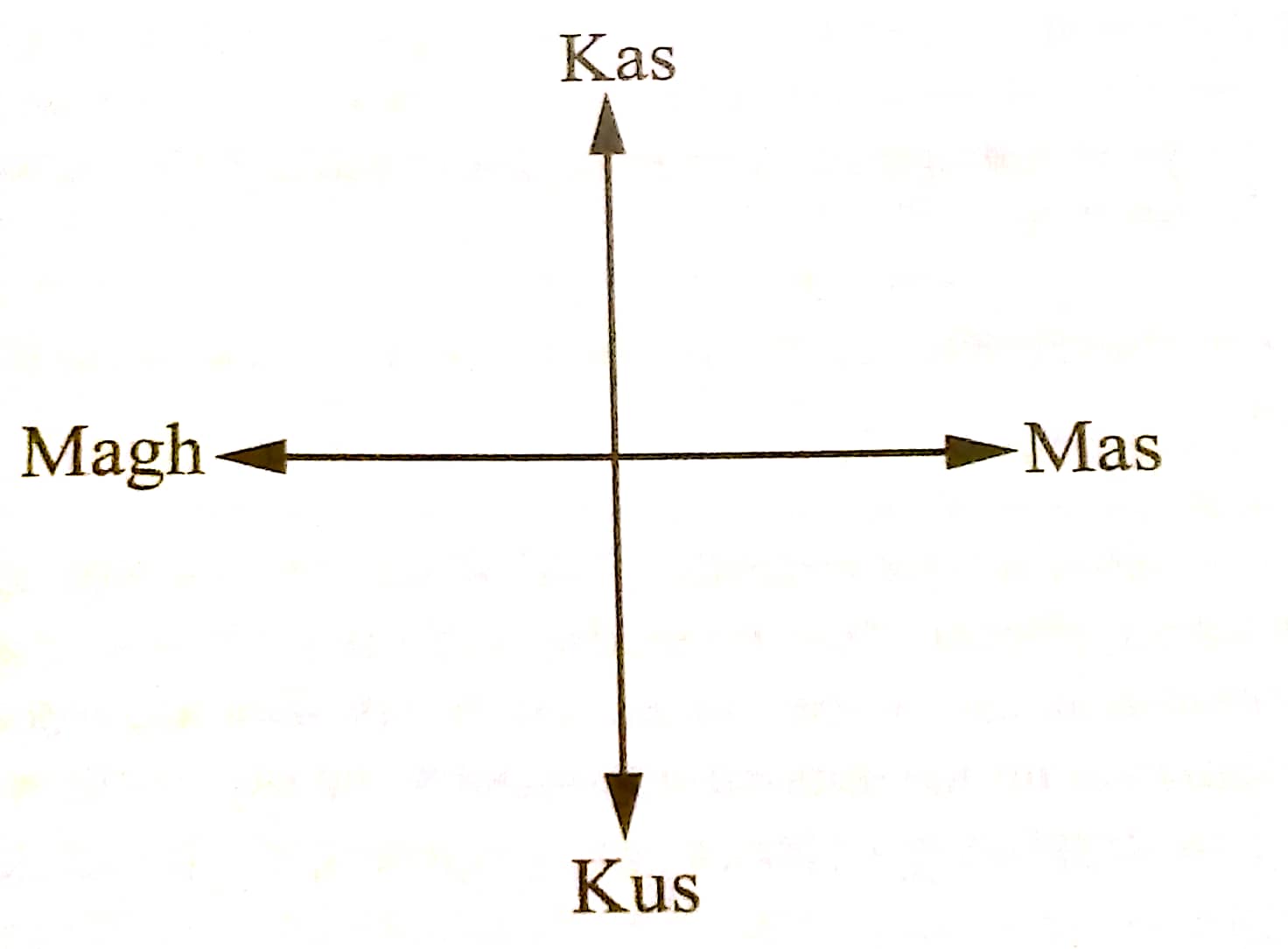
3.DIRA(uelekeo wa kaskazini): Husaidia kuonesha uelekeo katika ramani ambao kwa kawaida huwasilishwa na alama ya ncha ya kaskazini.Alama hii inamwezesha msomaji kubaini pande zingine za dunia katika ramani kama vile Mashariki,Magharibi, Kaskazini na kusini.
PANDE KUU NNE ZA DUNIA
Published from Blogger Prime Android App
4.UFUNGUO: Hufanya kazi ya kufafanua ishara na alama zote zilizotumika katika ramani.
5.SKELI:Hii Hufanya kazi ya kuonesha uhusiano wa umbali uliotumika katika ramani na umbali halisi katika ardhi.mfano sentimeta moja kwenye ramani inawakilisha kilometa kumi kwenye ardhi
6.MISTARI YA GRIDI:Hii ni mistari inayogawanya ramani katika miraba.Mistari hii inasaidia kuweza kupata maeneo mahususi kwenye ramani.Kila mraba una namba au herufi inayokusaidia kupata vitu kwa urahisi
7.CHANZO:Kunaeleza mahali palipotumika kupata taarifa zilizowasilishwa kwenye ramani
Ramani ya Tanzania kuonesha vipengele muhimu vya ramani
Published from Blogger Prime Android App
SIFA ZA RAMANI
1.Isomeke na kutafsiriwa kwa urahisi
2.Ioneshev vipengele vyote muhimu vya ramani
3.Iwakilishe maeneo na umbali halisi pamoja na kuweka vitu kwa usahihi
4.Itumie rangi na maandishi yanayoonekana ili kumsaidia msomaji kuelewa vizuri
5.Ioneshe taarifa pekee zinazohitajika kwa madhumuni husika
6.Itumie alama,rangi na mitindo inayofanana kwenye ramani
7.Iwe na taarifa za hivi karibuni ili kuhakikisha kila kitu kinachooneshwa ni sahihi.

UMUHIMU WA RAMANI KATIKA MAISHA
1.Kujifunza kuhusu maeneo mbalimbali
2.kufahamu umbali kutoka sehemu moja hadi nyingine
3.kufahamu uelekeo wa kufuata ili kufika tulikokusudia
4.kupanga safari zetu kwa kubaini Barabara Bora, njia za mkato
5.kuyafahamu mazingira yetu na vitu vilivyomo
6.kusaidia kujifunza kuhusu hali ya hewa katika maeneo mbalimbali
7.kuonesha mahali ambapo rasilimali muhimu za nchi zinapatikana
8.kuonesha makazi na idadi ya watu katika maeneo tofauti
9.kujua mipaka ya kiutawala
10.kuonesha vivutio vya utalii mf.mlima Kilimanjaro
11.Kusaidia kuelewa historia ya mahali kwa kuonesha jinsi palivyobadilika 

KIPIMIO CHA RAMANI
Ni uwiano kati ya umbali halisi na umbali ulioko kwenye ramani.
Zipo aina tatu za ramani ambazo ni
1.Kipimio kikubwa cha ramani
Hiki ni kipimio ambacho hutumika kuwakilisha maeneo madogo kama vile majengo, viwanja vya michezo na mashamba. Kipimio hiki huoneshwa kwa tarakimu kati ya 1:5,000 au 1:10,000 na 1:25,00

2.Kipimio cha kati cha ramani
Hiki ni kipimio ambacho hutumika kuwakilisha maeneo ya miji, mkoa na wilaya. Kipimio hiki huoneshwa kwa tarakimu za kati ya 1:50,000 na 1:250,000.

3.Kipimio kidogo cha ramani 
Hiki ni kipimio ambacho hutumika kuwakilisha maeneo makubwa sana kama vile nchi, mabara na dunia. Kipimio hiki huoneshwa kwa tarakimu zenye thamani kubwa kati ya 1:5000,000 na 1:1,000,000

Uwasilishaji wa ramani 
Kipimio cha ramani kinaweza kuwasilishwa kwa njia tatu ambazo ni
1.Njia ya sentensi 
Mfano:
Namna ya kuonesha kipimio hicho kwa njia ya sentensi itakuwa:"sentimeta moja kwa kilometa moja"
2.Njia ya uwiano au sehemu 
Njia hii ya kuonesha kipimio cha ramani Kwa uwiano au sehemu vikiwa katika thamani au vipimo vya aina moja kwa mfano 1:50,000 au humaanisha sentimeta moja kwenye ramani inawakilisha sentimeta elfu hamsini kwenye ardhi.Ikiwa sentimeta moja kwenye ramani inawakilisha kilometa moja kwenye ardhi ni lazima kilometa hiyo moja ibadilishwe kwenye sentimeta
                            Km1=M1000
                              M1=Sm100
            Kwa hiyo Km1=Sm100×1:100,00

Kwa njia ya uwiano hii itaoneshwa hivi 1:100,000
Kwa njia ya sentensi itaoneshwa hivi ¹/100,000
3.Njia ya mstari
Njia hii mstari huchorwa na kugawanywa katika sehemu mbili.sehemu ya kwanza kipimio kimegawanywa katika sehemu ndogondogo na sehemu ya pili inaonesha vipimio kamili
MAP READING
Published from Blogger Prime Android App
A map is a visual representation of an area, showing physical features, political boundaries, and other important details. Maps can be used for various purposes, such as navigation, education, planning, and analysis. 

Here are some common types of maps and their uses:

1. **Physical Map**: Shows natural features like mountains, rivers, and lakes. It often uses colors and shading to represent different elevations and terrain types.

2. **Political Map**: Highlights governmental boundaries such as countries, states, and cities. It also shows the locations of major cities and significant political boundaries.

3. **Topographic Map**: Depicts the shape and elevation of the terrain using contour lines. These maps are useful for hikers, engineers, and geologists.

4. **Thematic Map**: Focuses on specific topics or themes, such as population density, climate, economic activities, or vegetation.

5. **Road Map**: Displays highways, roads, and transportation networks. It is often used for navigation and travel planning.

6. **Climate Map**: Shows the various climate zones of an area, often using colors to represent different climate types such as tropical, arid, and temperate.

7. **Historical Map**: Provides information about how a particular area looked in the past, showing historical boundaries, events, or significant changes over time.

8. **Geological Map**: Illustrates the types and distribution of rocks and minerals in a particular area. It is often used by geologists for studying the Earth's structure.

Maps are essential tools for a variety of reasons, serving numerous purposes and benefiting various fields. Here are some key reasons why maps are important:

1. **Navigation and Travel**: Maps help individuals find their way from one location to another, whether by foot, car, plane, or boat. Road maps, GPS maps, and nautical charts are crucial for safe and efficient travel.

2. **Geographical Understanding**: Maps provide a visual representation of the Earth's surface, helping people understand the layout of continents, countries, and cities. They help in learning about different regions, their features, and their relative locations.

3. **Urban Planning and Development**: City planners and developers use maps to design infrastructure, plan new developments, and ensure efficient land use. Maps help in zoning, transportation planning, and the placement of public facilities.

4. **Disaster Management and Emergency Response**: Maps are critical in disaster management for identifying vulnerable areas, planning evacuation routes, and coordinating rescue operations. They help responders understand the impact and extent of natural disasters like earthquakes, floods, and hurricanes.

5. **Environmental Conservation**: Maps aid in monitoring and managing natural resources, such as forests, water bodies, and wildlife habitats. They help in conservation efforts by identifying protected areas and tracking changes in the environment.

6. **Research and Education**: Maps are valuable tools for scientific research and education. They help researchers study geographical patterns, analyze data, and present findings. In education, maps are used to teach geography, history, and environmental science.

7. **Military and Defense**: Maps are essential for military operations, providing information about terrain, strategic locations, and enemy positions. They aid in planning and executing missions.

8. **Communication and Visualization**: Maps are effective tools for visualizing complex data and communicating information. Thematic maps, for example, can show population density, climate zones, or economic activities, making it easier to understand and analyze patterns.

9. **Tourism and Recreation**: Maps guide tourists to attractions, parks, and cultural sites. They help in exploring new places, planning trips, and discovering points of interest.

10. **Historical Analysis**: Historical maps provide insights into past events, changes in political boundaries, and the development of regions over time. They are valuable resources for historians and researchers.

Maps contain several essential elements that help convey geographical information effectively. Here are the key components commonly found in maps:

1. **Title**: Indicates the subject or purpose of the map, providing context to the viewer.

2. **Legend (Key)**: Explains the symbols, colors, and patterns used on the map, allowing the viewer to understand what each element represents.

3. **Scale**: Shows the relationship between distances on the map and actual distances on the ground. It can be represented as a ratio, a bar scale, or a verbal statement (e.g., "1 inch = 1 mile").

4. **Compass Rose**: Indicates the cardinal directions (North, South, East, and West) to help the viewer orient the map.

5. **Grid**: A network of intersecting lines (latitude and longitude or a coordinate system) that helps locate specific points on the map.

6. **Labels**: Names and descriptions of places, features, and points of interest on the map, such as cities, rivers, mountains, and roads.

7. **Symbols**: Icons or graphics used to represent specific features, such as airports, hospitals, parks, and landmarks.

8. **Boundaries**: Lines that define political or administrative areas, such as country borders, state lines, and city limits.

9. **Inset Map**: A smaller map within the main map that provides additional detail or context for a specific area.

10. **Source and Date**: Information about the map's creator, the data used, and the publication date, which helps assess the map's accuracy and relevance.

MAP SCALE
A map scale is a crucial element of a map that shows the relationship between distances on the map and the actual distances on the ground. It allows the user to understand how much real-world distance is represented by a specific distance on the map. There are three main types of map scales:

1. **Ratio Scale (or Representative Fraction)**: This scale expresses the ratio between map distance and ground distance as a fraction or ratio, such as 1:50,000. This means that one unit of measurement on the map (e.g., 1 inch or 1 centimeter) represents 50,000 of the same units on the ground. For example, 1 cm on the map equals 50,000 cm (or 500 meters) in reality.

2. **Bar Scale (or Graphic Scale)**: This scale is a visual representation, usually a bar or line marked with units of distance. It allows the user to measure distances directly using the scale bar. It remains accurate even if the map is enlarged or reduced.

3. **Verbal Scale (or Statement Scale)**: This scale uses words to describe the ratio of map distance to ground distance, such as "1 inch equals 1 mile" or "1 centimeter equals 10 kilometers." It provides an easy-to-understand description of the scale.

The concept of scale is essential in various contexts for several important reasons:

1. **Accuracy in Representation**: Scale allows for the accurate representation of large areas or objects on a smaller medium, such as a map or blueprint. This enables us to visualize and analyze geographical regions, architectural designs, or any other spatial information effectively.

2. **Understanding Proportions**: Scale helps us understand the relative size and proportion of different elements within a representation. For example, in a scaled drawing, we can accurately compare the sizes of rooms, buildings, or landscapes.

3. **Navigation and Travel**: In maps, scale is crucial for determining distances between locations. It helps travelers and navigators estimate travel times and plan routes efficiently.

4. **Data Visualization**: Scale is important in creating graphs, charts, and diagrams. It ensures that data is presented accurately and proportionally, making it easier to interpret and analyze trends, patterns, and relationships.

5. **Scientific Research**: Scale is vital in various scientific fields, such as biology, astronomy, and geology. It allows researchers to study phenomena at different levels, from the microscopic to the cosmic, and understand their implications in a broader context.

6. **Modeling and Simulation**: Scale is used in creating models and simulations, whether in engineering, urban planning, or environmental studies. Scaled models help visualize and test scenarios before implementing them in the real world.

7. **Art and Design**: Scale is important in art and design, allowing artists and designers to create proportionate and aesthetically pleasing works. It helps in creating detailed miniatures, replicas, or scaled-up versions of objects.

8. **Educational Tools**: Scales are used in educational tools, such as globes, anatomical models, and historical replicas, to help students understand complex concepts in a tangible and relatable manner.


Tuesday, February 4, 2025

CELLS

CELLS

Cells are the basic structural and functional units of all living organisms. They are often referred to as the "building blocks of life." 

Here are some key points about cells:

1. **Types of Cells**: Cells can be broadly classified into two main types:
   - **Prokaryotic Cells**: These cells lack a true nucleus and membrane-bound organelles. Examples include bacteria and archaea.
Published from Blogger Prime Android App

   - **Eukaryotic Cells**: These cells have a true nucleus and membrane-bound organelles. Examples include animal cells, plant cells, fungi, and protists.An animal cell is a type of eukaryotic cell that contains various organelles, each with specific functions.

 Here are the main components of an animal cell:

1. **Cell Membrane**: A flexible, semi-permeable barrier that surrounds the cell, controlling the movement of substances in and out of the cell.

2. **Cytoplasm**: A gel-like substance inside the cell that contains the organelles and is the site of various metabolic processes.

3. **Nucleus**: The control center of the cell, containing DNA and responsible for regulating gene expression and cell division.

4. **Nucleolus**: Located within the nucleus, it is involved in the production of ribosomes.

5. **Ribosomes**: Tiny organelles that are the site of protein synthesis, either floating in the cytoplasm or attached to the endoplasmic reticulum.

6. **Endoplasmic Reticulum (ER)**: A network of membranes involved in protein and lipid synthesis. It comes in two forms:
   - **Rough ER**: Studded with ribosomes and involved in protein synthesis.
   - **Smooth ER**: Lacks ribosomes and is involved in lipid synthesis and detoxification.

7. **Golgi Apparatus**: A stack of membranes that modify, sort, and package proteins and lipids for storage or transport out of the cell.

8. **Mitochondria**: The powerhouse of the cell, responsible for producing energy (ATP) through cellular respiration.

9. **Lysosomes**: Contain digestive enzymes that break down waste materials and cellular debris.

10. **Centrioles**: Involved in cell division, helping to organize the mitotic spindle.

11. **Cytoskeleton**: A network of protein filaments that provide structural support, help maintain the cell's shape, and facilitate movement.

12. **Vesicles**: Small membrane-bound sacs that transport substances within the cell.

Published from Blogger Prime Android App

A plant cell is a type of eukaryotic cell that has unique structures and functions compared to animal cells. Here are the main components of a plant cell:

1. **Cell Wall**: A rigid outer layer that provides structure, support, and protection. It is primarily composed of cellulose.

2. **Cell Membrane**: A semi-permeable barrier just inside the cell wall that controls the movement of substances in and out of the cell.

3. **Cytoplasm**: The gel-like substance within the cell that contains organelles and is the site of various metabolic processes.

4. **Nucleus**: The control center of the cell that contains DNA and regulates gene expression and cell division.

5. **Nucleolus**: Found within the nucleus, it is involved in the production of ribosomes.

6. **Chloroplasts**: Organelles that contain chlorophyll and are the site of photosynthesis, converting sunlight into chemical energy.

7. **Mitochondria**: The powerhouse of the cell, responsible for producing energy (ATP) through cellular respiration.

8. **Vacuole**: A large, central sac that stores water, nutrients, and waste products. It also helps maintain turgor pressure, keeping the cell rigid.

9. **Endoplasmic Reticulum (ER)**: A network of membranes involved in protein and lipid synthesis. It comes in two forms:
   - **Rough ER**: Studded with ribosomes and involved in protein synthesis.
   - **Smooth ER**: Lacks ribosomes and is involved in lipid synthesis and detoxification.

10. **Golgi Apparatus**: A stack of membranes that modify, sort, and package proteins and lipids for storage or transport out of the cell.

11. **Ribosomes**: Small organelles that are the site of protein synthesis, either floating in the cytoplasm or attached to the rough ER.

12. **Plasmodesmata**: Channels between plant cell walls that allow for transport and communication between cells.

13. **Peroxisomes**: Organelles that contain enzymes for breaking down fatty acids and detoxifying harmful substances.

14. **Cytoskeleton**: A network of protein filaments that provide structural support, help maintain the cell's shape, and facilitate movement.
Published from Blogger Prime Android App


2. **Structure of Eukaryotic Cells**: Eukaryotic cells have a complex structure with various organelles, each performing specific functions. Key components include:
   - **Nucleus**: Contains the cell's genetic material (DNA) and controls cell activities.
   - **Mitochondria**: The powerhouse of the cell, responsible for producing energy (ATP) through cellular respiration.
   - **Endoplasmic Reticulum (ER)**: A network of membranes involved in protein and lipid synthesis. It includes rough ER (with ribosomes) and smooth ER (without ribosomes).
   - **Golgi Apparatus**: Modifies, sorts, and packages proteins and lipids for transport.
   - **Lysosomes**: Contain digestive enzymes that break down waste materials and cellular debris.
   - **Ribosomes**: Sites of protein synthesis.
   - **Cytoplasm**: A gel-like substance that fills the cell and contains organelles.
   - **Cell Membrane**: A semi-permeable barrier that controls the movement of substances in and out of the cell.
   - **Cytoskeleton**: A network of protein filaments that provide structural support and facilitate movement.

3. **Functions of Cells**: Cells perform various functions essential for life, including:
   - **Metabolism**: Chemical reactions that provide energy and build cellular components.
   - **Growth and Reproduction**: Cells grow, divide, and replicate their genetic material.
   - **Response to Stimuli**: Cells can sense and respond to changes in their environment.
   - **Homeostasis**: Cells maintain a stable internal environment.

4. **Specialized Cells**: In multicellular organisms, cells differentiate into specialized types with distinct functions. Examples include nerve cells, muscle cells, blood cells, and skin cells.

5. **Cell Division**: Cells reproduce through processes such as mitosis (for growth and repair) and meiosis (for sexual reproduction
THE CONCEPT OF BIOLOGY
Biology is the scientific study of life and living organisms, encompassing their structure, function, growth, evolution, distribution, and taxonomy. It's a vast and diverse field that explores all aspects of life, from the molecular level to entire ecosystems.

 Here are some key areas within biology:

1. **Cell Biology**: The study of cells, their structure, function, and processes. It includes the study of cell division, cell signaling, and cell metabolism.

2. **Genetics**: The study of heredity and variation in organisms. It involves understanding how traits are passed from one generation to the next through genes.

3. **Ecology**: The study of interactions between organisms and their environment. It looks at ecosystems, biodiversity, and the impact of human activity on the natural world.

4. **Evolutionary Biology**: The study of the origins and changes in the diversity of life over time. It involves understanding natural selection, adaptation, and speciation.

5. **Physiology**: The study of the functions and mechanisms in living organisms. It covers various systems within organisms, such as the nervous, circulatory, and respiratory systems.

6. **Anatomy**: The study of the physical structure of organisms. It includes the examination of organs, tissues, and cells.

7. **Microbiology**: The study of microorganisms, including bacteria, viruses, fungi, and protozoa. It explores their roles in health, disease, and the environment.

8. **Botany**: The study of plants, including their physiology, structure, genetics, ecology, distribution, and classification.

9. **Zoology**: The study of animals and their behavior, physiology, classification, and distribution.

10. **Biochemistry**: The study of the chemical processes within and related to living organisms. It bridges biology and chemistry by looking at processes such as enzyme function, metabolism, and DNA replication.

11. **Molecular Biology**: The study of biological molecules and their interactions. It focuses on the molecular mechanisms that underlie biological processes.

Studying biology is essential for understanding the complexities of life and the natural world. Here are some key reasons why studying biology is important:

1. **Understanding Living Organisms**: Biology helps us comprehend the structure, function, and behavior of living organisms, from microscopic bacteria to complex multicellular organisms like humans.

2. **Advancing Medical Science**: Knowledge of biology is fundamental to medical research and healthcare. It enables the development of treatments, vaccines, and diagnostic tools to combat diseases and improve human health.

3. **Environmental Conservation**: Biology provides insights into ecosystems and biodiversity, helping us understand the impact of human activities on the environment and informing conservation efforts to protect endangered species and habitats.

4. **Improving Agriculture**: Biological research contributes to advancements in agriculture, including the development of disease-resistant crops, sustainable farming practices, and biotechnology applications that enhance food production.

5. **Biotechnology and Innovation**: Biology is at the core of biotechnology, leading to innovations in fields such as genetic engineering, pharmaceuticals, and biofuels, which have significant societal and economic impacts.

6. **Solving Global Challenges**: Biological knowledge is crucial for addressing global challenges such as climate change, food security, and public health crises. It provides the scientific foundation for developing solutions to these pressing issues.

7. **Enhancing Education and Critical Thinking**: Studying biology fosters critical thinking, analytical skills, and a scientific mindset. It encourages curiosity and a deeper appreciation for the natural world.

8. **Personal Health and Well-being**: Understanding biology empowers individuals to make informed decisions about their health, nutrition, and lifestyle, leading to better overall well-being.

Biology is a dynamic and ever-evolving field that continually contributes to our knowledge and quality of life. If you have any specific questions or want to explore a particular area of biology further, feel free to ask!
HOMOPHONES IN ENGLISH LANGUAGE
WHAT IS HOMOPHONES? 
Are words that are pronounced the same but have different meanings, often with different spellings. In other words homophones are words that sound identical when spoken, but have different definitions and often, different spellings.

Here are some examples of homophones 
1.for and four
2.bored and board
3.break and brake
4.ate and eight
5.One and won
6.Made and maid
7.Tee and tea
8.Stare and stair
Homophones can be confusing, special when listening to someone speak, as the words are pronounced the same but have different meanings. However, understanding homophones can also be
 
FOR WATCHING VIDEO CLICK HERE 
ANTONYMS IN ENGLISH LANGUAGE
What is Antonyms?
Antonyms are words that have opposite meanings
Example
1.Big-Small
2.Inside-Outside
3.Happy-Sad
4.Boy-Girl
5.Open-Close
6.Long-short
7.On-Under
8.Fast-Slow
9.Up-Down
10.Hot-Cold

Do you know? 
Antonyms are classified into different types
1.Gradable antonyms: these are antonyms that exist on a spectrum or continuum,such as hot-cold or Big-small.

2.Complementary antonyms: These are antonyms that are absolutely opposite, such as alive-dead or true-false

3.Relational antonyms: These are antonyms that are related to each other, such as teacher-student or buyer-seller or doctor-patient

Understanding antonyms is important for language learning, vocabulary building, and effective communication

FOR WATCHING VIDEO CLICK HERE

Advertisement